
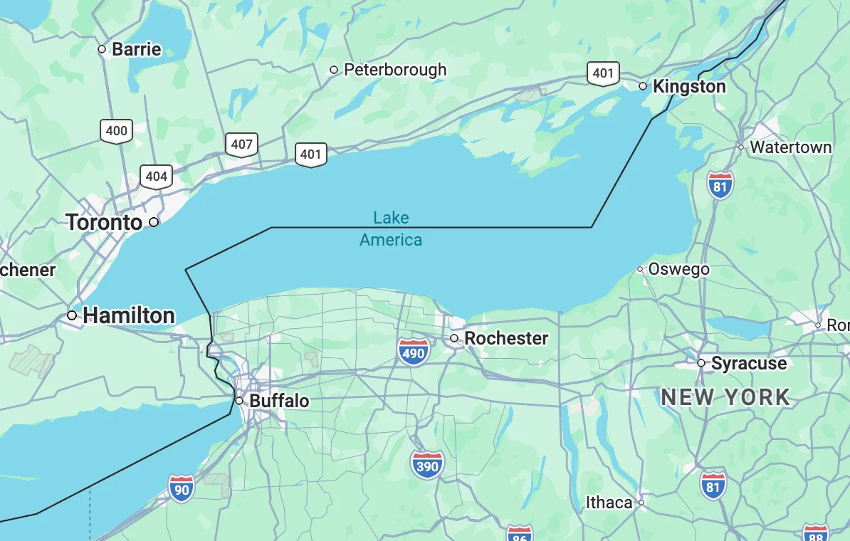
The digital landscape of North American geography underwent a significant shift this weekend as Google Maps officially updated the name of Lake Ontario to "Lake America" for users within the United States. The change, which appeared on the platform late Saturday evening, follows a formal executive order issued by President Donald Trump earlier in the week. This rebranding of the easternmost Great Lake marks the latest escalation in a series of diplomatic and economic tensions between Washington and Ottawa, specifically targeting the Canadian province of Ontario, which serves as the nation’s economic and political heartland.
While the physical body of water remains shared between the state of New York and the province of Ontario, its digital representation has now been bifurcated. The move reflects a growing trend of utilizing geographic nomenclature as a tool of foreign policy and economic leverage. As of Sunday, users accessing Google Maps from U.S.-based IP addresses are presented with the "Lake America" label, while the traditional "Lake Ontario" remains visible to users in Canada and other international territories.
The Executive Order and the Trade Feud
The catalyst for this geographic rebranding was an executive order signed by President Trump on Thursday. According to White House officials, the order was a direct response to an ongoing feud over tariffs and trade imbalances with Canada. The President has frequently criticized Canada’s trade policies, particularly regarding the automotive and dairy sectors, which are heavily concentrated in the province of Ontario. By ordering the rebranding of the lake in all official government databases, the administration seeks to assert American influence over shared natural resources and signal its dissatisfaction with the current diplomatic status quo.
This is not an isolated incident in the current administration’s approach to cartography. In January 2025, a similar executive order was issued to rename the Gulf of Mexico as the "Gulf of America." That change was framed as part of a broader strategy to redefine U.S. maritime and economic boundaries amid trade negotiations with Mexico. The successful implementation of the Gulf name change across federal agencies and private mapping services provided the blueprint for the current Lake Ontario rebranding.
Technical Implementation and the Role of GNIS
The speed with which Google and other tech giants have adopted the new naming convention is tied to the federal government’s management of geographic data. The U.S. Department of the Interior maintains the Geographic Names Information System (GNIS), a database that serves as the authoritative source for geographic names used by federal agencies, state governments, and the private sector.
When the GNIS was updated late last week to reflect the President’s order, it triggered an automatic review process for major mapping providers. While private organizations like Google, Apple, and Microsoft are not legally compelled to follow GNIS designations, they historically adhere to these official records to ensure consistency with roadway signage, government literature, and aviation charts.
As of Sunday morning, the GNIS public search portal for domestic names showed a pending update for the entry previously known as Lake Ontario. A notice on the site informed users that the database was "in the process of being updated to reflect this name change" to Lake America. Google was the first major provider to push the update to its live production environment, with a company spokesperson confirming that the rollout began shortly after the federal records were modified.
Industry Responses and Geographic Policy
The tech industry’s response to the order has been varied, highlighting the complex intersection of corporate policy and national sovereignty. Google issued an unsigned statement explaining its decision to implement the change: "People using Maps in the US will see ‘Lake America,’ those in Canada will continue to see ‘Lake Ontario,’ and those outside of the US and Canada will see both names. These updates follow our long-standing policy for bodies of water with names that vary from country to country."
This "geofencing" approach is a standard practice for Google in regions with disputed borders or contested naming conventions, such as the Sea of Japan (referred to as the East Sea in South Korea) or the Persian Gulf (referred to as the Arabian Gulf in several Middle Eastern nations). By tailoring the display to the user’s location, Google attempts to remain neutral while complying with local governmental expectations.
Apple Maps and Microsoft’s Bing Maps have not yet reflected the "Lake America" label, though industry analysts expect them to follow suit within the coming days to maintain alignment with U.S. federal data. Conversely, MapQuest has taken a defiant stance. In a social media post that gained significant traction on Sunday, the company stated, "We’re not changing it," signaling a rare instance of a mapping provider explicitly rejecting a federal naming directive.
Open-Source Mapping and Public Debate
The rebranding has sparked a heated debate within the open-source mapping community. OpenStreetMap (OSM), a collaborative project often described as the "Wikipedia of maps," has become a primary forum for this discussion. OSM technology powers the navigation systems for numerous high-profile services, including Uber and Lyft.
The OSM community is currently divided on how to handle the change. Some contributors argue that the map should reflect the most widely recognized international name, while others contend that the map should reflect the official name recognized by the sovereign power controlling the territory. Currently, OpenStreetMap’s policy allows for multiple name tags, giving developers who use their data the choice of which name to prioritize based on their target audience.
Historical and Economic Significance of Lake Ontario
To understand the weight of this rebranding, one must consider the historical and economic importance of Lake Ontario. It is the smallest of the Great Lakes by surface area (approximately 7,340 square miles) but the 14th largest lake in the world. It serves as a vital conduit for international trade via the St. Lawrence Seaway, connecting the Atlantic Ocean to the industrial heartland of North America.
The lake supports a massive regional economy. On the Canadian side, the "Golden Horseshoe" region, which includes Toronto, is home to nearly 25% of Canada’s population and is a global hub for finance, technology, and manufacturing. On the American side, the lake borders major New York population centers like Rochester and Oswego and provides essential cooling water for nuclear power plants and irrigation for the state’s agricultural sector.
Critics of the name change argue that erasing "Ontario" from American maps is a symbolic attempt to decouple the lake’s identity from the Canadian province. Supporters, however, view it as an assertion of American "blue economy" interests and a necessary psychological tactic in a high-stakes trade war.
Timeline of Recent Geographic Rebranding Efforts
The shift toward "Lake America" is part of a rapid sequence of events that has redefined North American cartography in less than six months:
- January 15, 2025: President Trump issues an executive order to rename the Gulf of Mexico as the "Gulf of America" in U.S. federal databases.
- January 29, 2025: The Department of the Interior completes the update to the GNIS database. Google and Apple Maps adopt the "Gulf of America" name for U.S. users.
- February 2025: Trade tensions with Canada escalate following the imposition of new tariffs on Canadian-manufactured steel and aluminum.
- May 22, 2025: President Trump signs the executive order for the rebranding of Lake Ontario, citing the need to "reclaim American heritage" in the Great Lakes region.
- May 24, 2025: Google Maps updates its interface for U.S. users to display "Lake America."
- May 25, 2025: MapQuest publicly declines to adopt the new name, while Apple and Bing remain in a "processing" state.
Diplomatic and Maritime Implications
The diplomatic fallout from the rebranding is expected to be significant. While the Canadian government has not yet issued a formal retaliatory order, political analysts in Ottawa suggest that Canada could respond by renaming shared landmarks on their own maps or increasing regulatory hurdles for American vessels passing through Canadian-controlled waters of the lake.
From a maritime perspective, the change creates a potential for confusion in cross-border navigation. While commercial shipping relies on international maritime charts—which typically follow the International Hydrographic Organization (IHO) standards—recreational boaters and local logistics companies increasingly rely on consumer-grade digital maps like Google Maps. If a vessel departing from Sackets Harbor, New York, is using a device that says "Lake America" while the receiving port in Kingston, Ontario, refers to the same body of water as "Lake Ontario," it introduces a layer of linguistic friction into daily operations.
Analysis: The Future of Digital Sovereignty
The rebranding of Lake Ontario serves as a case study in the "balkanization" of the digital world. For decades, the internet and its associated tools, like global maps, were viewed as unified platforms that provided a single version of reality. However, as national governments increasingly exert pressure on tech companies to reflect specific political viewpoints or sovereign claims, the digital world is becoming fragmented.
This trend suggests that "truth" on a digital map is becoming a function of the user’s physical location. If a user in Buffalo sees a different world than a user in Fort Erie—just a few miles across the Niagara River—the shared sense of geography that has underpinned North American relations for over two centuries may begin to erode.
As the U.S. Department of the Interior continues to process the name change across all federal agencies, including the National Oceanic and Atmospheric Administration (NOAA) and the U.S. Coast Guard, the "Lake America" designation will become deeply embedded in the nation’s infrastructure. Whether this change remains a temporary artifact of a trade dispute or a permanent fixture of American cartography depends on the longevity of the current administration’s policies and the willingness of the international community to recognize the shift. For now, for millions of Americans, the waters of the eastern Great Lakes have a new, distinctly nationalistic name.
About the Author